
Abstract. The paper discusses the capabilities of operational satellite synthetic aperture radar imaging in wide-swath and very high-resolution modes for navigation safety and economic activity support in northern latitudes. It is shown that SAR data can be used to monitor ice conditions, detect vessels and maritime infrastructure, and observe water areas regardless of daylight and weather conditions. The study demonstrates the relevance of combining wide-swath imaging for large-area monitoring with detailed imaging for local analysis in marine surveillance tasks.
Keywords: Remote sensing of Earth, SAR imaging, northern latitudes, maritime safety, sea ice, vessel detection, space-based monitoring
Ensuring the safety of navigation and economic activity in northern latitudes requires the prompt acquisition of objective information on the state of the marine water area, ice conditions, vessel positions, and the condition of coastal infrastructure. The complexity of this task stems from the considerable extent of the monitored water areas, the variability of ice conditions, and the need for regular observation of remote regions. The aim of this paper is to analyze the capabilities of near-real-time satellite SAR imaging in wide-swath and very high-resolution modes for addressing these tasks.
Northern latitudes are among the most challenging regions for operational remote monitoring due to persistent cloud cover, limited daylight, and complex ice conditions. Under these conditions, synthetic aperture radar imaging, as an active remote sensing method, provides data acquisition regardless of time of day and, to a large extent, independent of weather conditions, which makes it valuable for monitoring ice and navigation conditions, detecting vessels, and analyzing movement in ice-covered waters.
Radar imaging can be carried out in wide-swath and detailed modes, which differ in swath width and spatial resolution. Wide-swath modes are intended for monitoring large water areas and extended route segments, while detailed modes provide analysis of local objects and small surface areas. The distinction between them is therefore a trade-off between coverage area and the degree of spatial detail, which is what makes their combined use valuable for operational monitoring tasks.
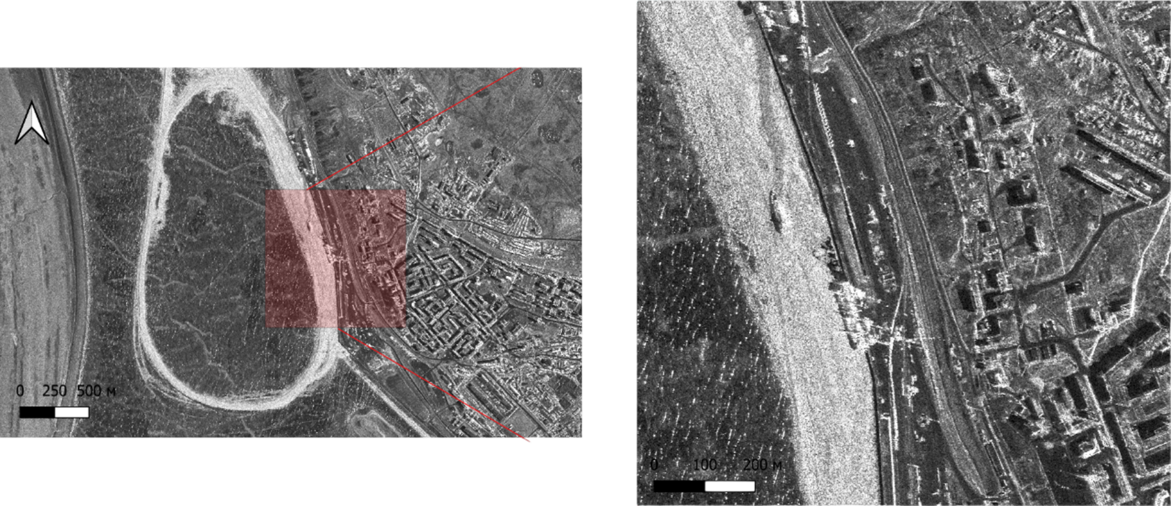
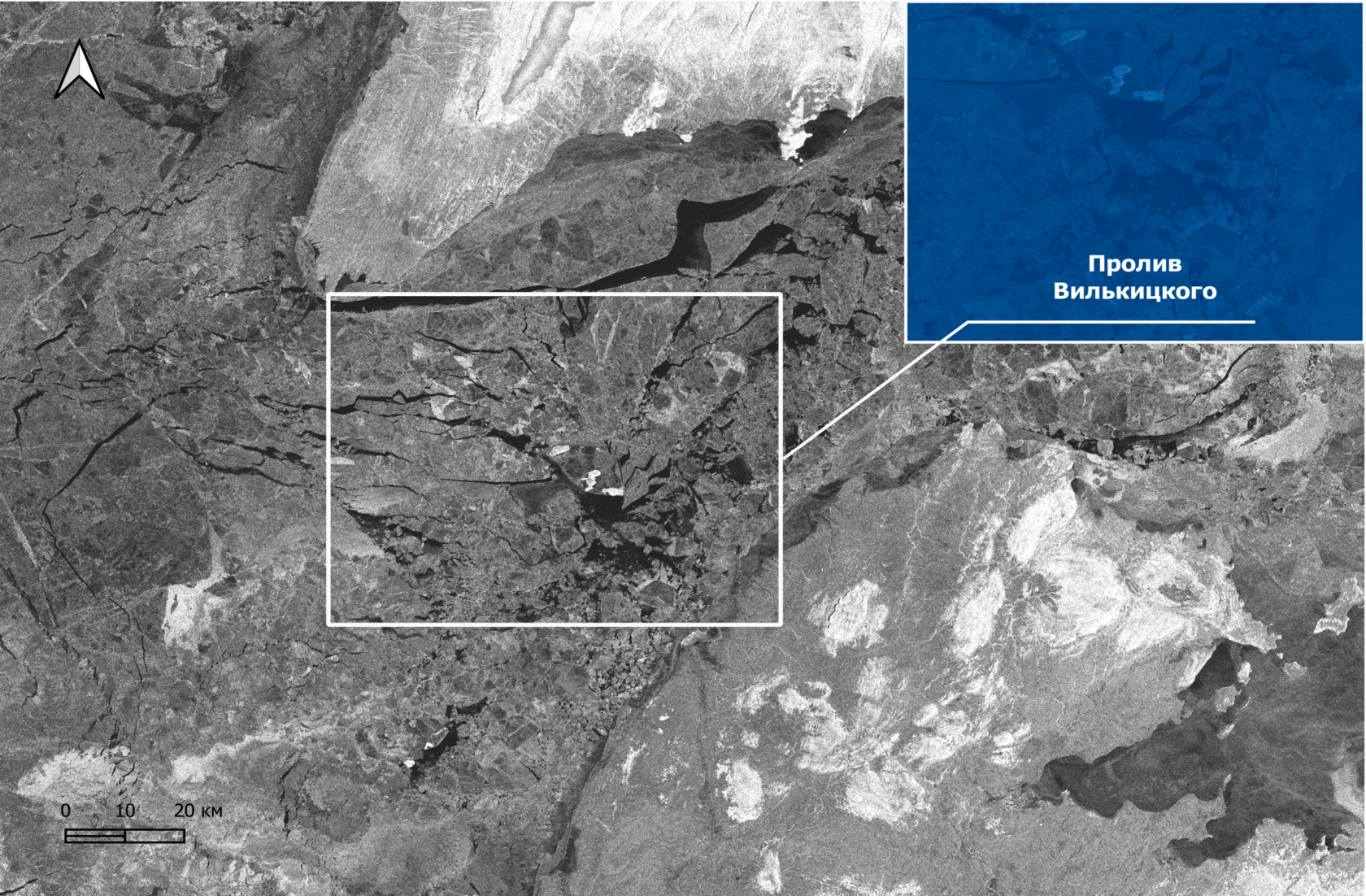
Monitoring Ice and Navigation Conditions
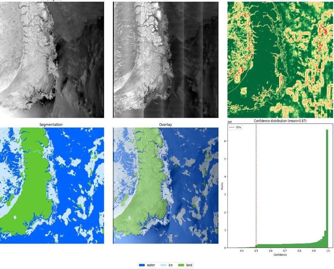
Machine learning methods and deep neural networks are widely used for thematic interpretation of radar images, enabling automatic segmentation of different surface types — including open water, ice cover, and land — as well as ice-type classification [1–3]. Fig. 3 shows an example of SAR image segmentation for the Arctic waters of the Kara Sea near the Novaya Zemlya archipelago. The open Sentinel-1 SAR Sea Ice Dataset [4] was used to train the model. A DeepLabv3+ architecture with a ResNet-50 encoder, widely used for semantic image segmentation tasks [5], was applied as the neural network architecture. The output is a thematic scene map highlighting the "water," "ice," and "land" classes, along with a confidence map characterizing the reliability of the segmentation.
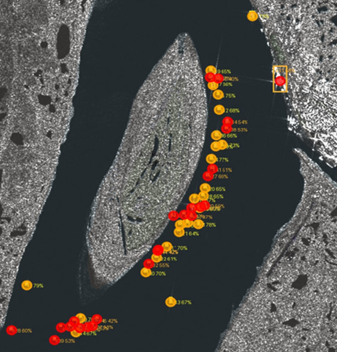
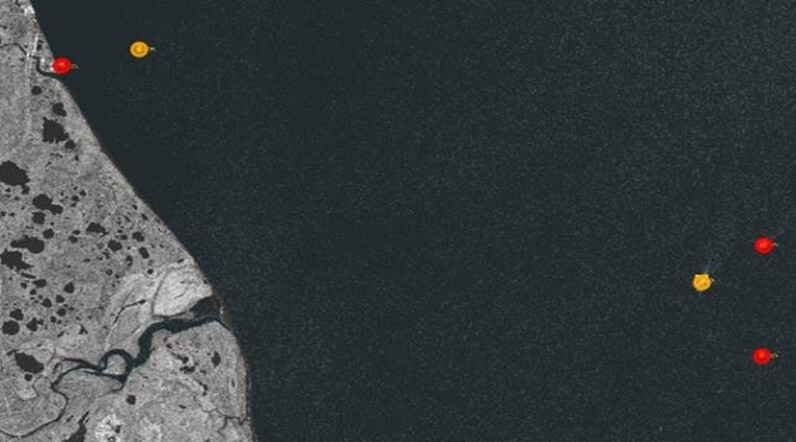
In addition to analyzing ice and navigation conditions, automatic vessel detection is an important task of operational radar monitoring of the maritime situation. In recent years, deep learning methods have been widely applied to this task, demonstrating high detection accuracy on complex SAR scenes [6, 7]. In this study, the analysis was carried out for radar scenes obtained in the areas of the Arctic ports of Dudinka and Sabetta, where a significant share of vessels are small craft, which requires choosing architectures that are robust to detecting small targets.
Several modern object detection architectures were considered for this task, including the YOLOv8 model, the specialized SLA-Net architecture, which accounts for differences between sea and coastal surfaces [8], and the MC-ASFF-ShipYOLO model, aimed at detecting small targets in SAR imagery [9]. Comparative analysis showed that the MC-ASFF-ShipYOLO architecture was the most effective for the scenes under consideration. This model uses a Monte Carlo attention module, which forms attention maps through random sampling across different scales and enhances features of small objects. In addition, the adaptive spatial feature fusion (ASFF) mechanism allows the network to dynamically determine the most informative feature scale for each region of the image, contributing to more robust detection of objects of different sizes. The experiments yielded values of mAP@0.5 = 0.90 and mAP@0.95 = 0.63, indicating the high effectiveness of the applied approach and its applicability to operational maritime traffic monitoring tasks in Arctic waters.
An important application of satellite radar imaging in northern latitudes is the identification and analysis of vessel tracks in ice conditions. This study used Sentinel-1 data acquired in IW (Interferometric Wide Swath) mode in VV and VH polarizations. This mode provides observation of extended water areas and is of practical interest for monitoring ice conditions and identifying traces of vessel movement. The use of VV and VH polarization data creates additional features for analyzing the ice surface and linear disruptions in its structure associated with vessel movement. After a vessel or icebreaker passes, the ice cover is broken up, forming an area that differs from the surrounding ice in terms of radar signal scattering characteristics. In the image, this can appear as an extended linear structure, distinguished by brightness and texture features. At the same time, automatic identification of a vessel track is a challenging task, since the observed structure can have variable width, non-uniform brightness, local gaps, and complex geometry. Additional difficulties are created by natural cracks, ice field boundaries, pressure-ridge zones, and transition areas between ice and open water. For this reason, the task is addressed using a step-by-step algorithm that includes image pre-processing, track candidate extraction, reconstruction of linear structures, and filtering of false objects [10]. The vessel track algorithm includes the following stages:
1. Image pre-processing. At this stage, a 3 × 3 median filter is applied to reduce the effect of speckle noise, typical of SAR data, while preserving the main linear structures of the image. Local brightness normalization is additionally performed to increase the contrast between the vessel track and the surrounding ice cover.
2. Track search. The algorithm searches for "seeds" – contrasting image areas whose pixel size is no smaller than a given threshold value. A morphological closing operation is applied to each detected "seed," after which the center, endpoints, and direction vectors from the center to the ends of the area are calculated. Within a given radius around the calculated directions, the algorithm searches for the most contrasting pixels, which are sequentially added to the track. This achieves a gradual extension of the track from each "seed" in both directions.
3. Track merging and trimming. In the final stage, intersecting or adjoining tracks are merged into a single structure. Branches that are too short or excessively wide, as well as fragments whose direction or thickness changes too frequently or sharply, are then trimmed. Such structures generally do not correspond to elements of a vessel track and more often correspond to cracks in the ice or other natural inhomogeneities of the ice cover.
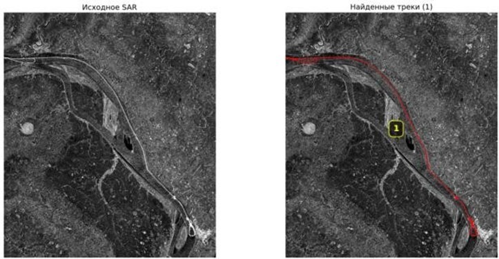
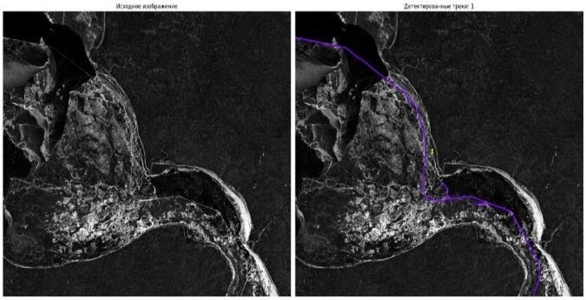
The proposed algorithm makes it possible to extract icebreaker tracks in radar images with acceptable accuracy and computational efficiency (Fig. 4). At the same time, two types of complex scenes were identified. The first involves images obtained during the period of initial ice formation, when vessel tracks have small width and low contrast; their main distinction from natural cracks lies in their smoother and more consistent geometry. The second involves scenes with complex ice conditions and a large number of cracks, including transition zones between ice and non-freezing sections of water (Fig. 5). This study uses an algorithmic approach rather than a machine-learning-based one, due to the absence of publicly available representative labeled data and the high labor intensity of manual annotation. A promising direction is a combined approach, in which machine learning methods are used for preliminary segmentation, while track extraction is performed by the proposed algorithm only within the target areas.
This paper examined the capabilities of near-real-time satellite radar imaging in wide-swath and high-resolution modes for maritime safety and economic activity support in northern latitudes. It was shown that wide-swath imaging modes are best suited for monitoring ice and navigation conditions over large water areas, while high-resolution data provide detailed analysis of local sites, port infrastructure objects, and vessels. The applicability of modern deep learning methods for thematic segmentation of SAR imagery and automatic vessel detection was also demonstrated, and the algorithmic approach to vessel track extraction showed promise for analyzing movement in ice conditions. The results confirm that the combined use of wide-swath and detailed radar imaging, together with automated data processing methods, is an effective tool for operational maritime monitoring in Arctic and other northern regions.
- Zhang Z., Liu Y., Li X. Deep Learning-Based Sea Ice Classification Using SAR Imagery // Remote Sensing. 2021. Vol. 13. № 3.
- Liu H., Zhang H., Wang Y. Sea Ice Classification Using Deep Convolutional Neural Networks and SAR Imagery // IEEE Geoscience and Remote Sensing Letters. 2018. Vol. 15. № 5. P. 781–785.
- Wang L., Scott K., Clausi D. Sea Ice Concentration Estimation from SAR Imagery Using Deep Learning // Remote Sensing of Environment. 2020. Vol. 237.
- Wang Y., Li X. Arctic Sea Ice Cover Data from Spaceborne SAR by Deep Learning // Science Data Bank. 2022. URL: https://www.scidb.cn/en/detail?dataSetId=771301999089025024 (accessed: 15.02.2026).
- Chen L.-C., Zhu Y., Papandreou G., Schroff F., Adam H. Encoder-Decoder with Atrous Separable Convolution for Semantic Image Segmentation // Proceedings of the European Conference on Computer Vision (ECCV). 2018. P. 801–818.
- Li Y., Zhang Q., Li X. A Survey of SAR Ship Detection Based on Deep Learning // Remote Sensing. 2021.
- Zhao Z., Shi Z. SAR Ship Detection Using Deep Learning: A Review // IEEE Geoscience and Remote Sensing Magazine. 2020.
- SLA-Net: Sea–Land-Aware Network for Ship Detection in SAR Images / Zhang X. [et al.] // IEEE Transactions on Geoscience and Remote Sensing. 2022.
- MC-ASFF-ShipYOLO: Ship Detection for SAR Images Based on Monte Carlo Attention and Adaptive Spatial Feature Fusion / Li Y. [et al.] // Remote Sensing. 2025.
- Li J., Chapman M., Peng J., Wang B. SAR Imagery Segmentation by Statistical Region Growing and Hierarchical Stepwise Optimization // IEEE Geoscience and Remote Sensing Letters. 2002. Vol. 1. № 4. P. 247–250.